Height: 80 feet
Trail Type: Dirt
Hike Distance: As long as you want it to be
Difficulty: 1
Beauty: 10
Overview:
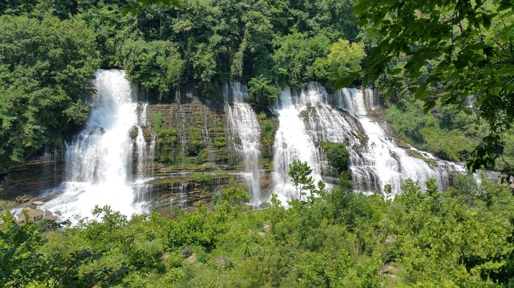
99% of the time, man-made waterfalls aren’t impressive or as enthralling as the real thing. Twin Falls represents the 1%. The Great Falls Dam, built in 1917, was considered a triumph of engineering after several failed attempts at damming the Caney Fork River, which was subject to unpredictable and volatile floods. The dam is located just downstream from the confluence of the Collins and Caney Fork Rivers. Even more, the Rocky River joins Caney Fork a few miles upstream from that. The result is a pretty big river that snakes its way down into the Tennessee Valley.
Just downstream from the dam, the Caney Fork, left in pretty pitiful shape from the massive 92-foot tall Great Falls Dam, flows along a ridge a couple hundred feet high. On the other side of the ridge flows the swollen Collins River before it joins Caney Fork on the other side of the dam. When the dam was built, the engineers had no idea that the ridge separating the Collins and Caney Fork Rivers was mostly hollow. When the waters began to back up and rise upon completion of the dam, water from the Collins River began spilling into cave openings in the ridge and pouring through the other side into the Caney Fork River. The result was Twin Falls, which is now the centerpiece for Rock Island State Park.
Twin Falls bursts from the side of the mountain down to the river below in one of the most unique scenes you’ll ever encounter. If you go in the middle of summer when the foliage is at its thickest, you feel like you’re in a tropical jungle despite the fact that massive power lines and industrial footprints lay just a few thousand feet upstream.
Directions:
If you’re coming from Burgess Falls, simply continue on TN highway 135 for 3.3 miles and turn right onto TN highway 136. Drive about 15.5 miles and turn right onto Powerhouse Road. Follow that road, which gets narrow in places, to the parking area. If you’re coming from any other direction, use your GPS.
Hike Description:
The parking area places you within sight of Twin Falls, and this view is already pretty great. You can take the wide, level trail downstream for as far as you want in order to get a front and center view of the falls. There are several places along the trail to hop down into the old riverbed, but it’s not maintained by the park service and I don’t know what kind of condition that part of the riverbed is in.
