Height: 35 feet
Trail Type: Gravel and dirt
Hike Distance: 1 mile round trip
Difficulty: 5
Beauty: 5
Overview:
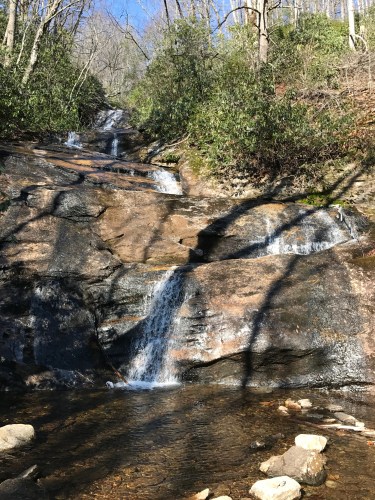
Setrock Creek is one of the many tributaries that flows down off of Mount Mitchell – which has several waterfalls of its own; but they’re inaccessible because most of the mountain is on private property. The falls slide down a series of smooth ledges and interestingly colored rock into a shallow pool. The waterflow, however, is usually pretty puny, so it’s best to come after a heavy rain. The trail is also on the Black Mountain Campground Property, so if you go during camping season, expect to have a lot of company.
Directions:
From the Roaring Fork Falls trailhead, go back out to South Toe River Road and turn left. Drive about three miles to the parking area to the left, opposite the entrance to the campground.
Hike Description:
From the parking area, walk over the bridge that crosses the South Toe River and enter the campground. Take the path named Briar Bottom Road and continue straight until the trail forks. Follow the Briar Bottom Bike Trail past the start of the Mount Mitchell Trail and over a new footbridge over Little Mountain Creek. The Setrock Creek Falls trail breaks to the right on the other side of the bridge. The falls are uphill a couple hundred yards away.
There’s an old dead hemlock that acts as a bridge over the creek to a closer viewing area at the base of the falls. If your balance is terrible, like mine, you can use some of the bigger rocks to hop across the creek and continue on. If water levels are up, it may not be safe to go much farther.
